
Sierra Nevada Checkerboard
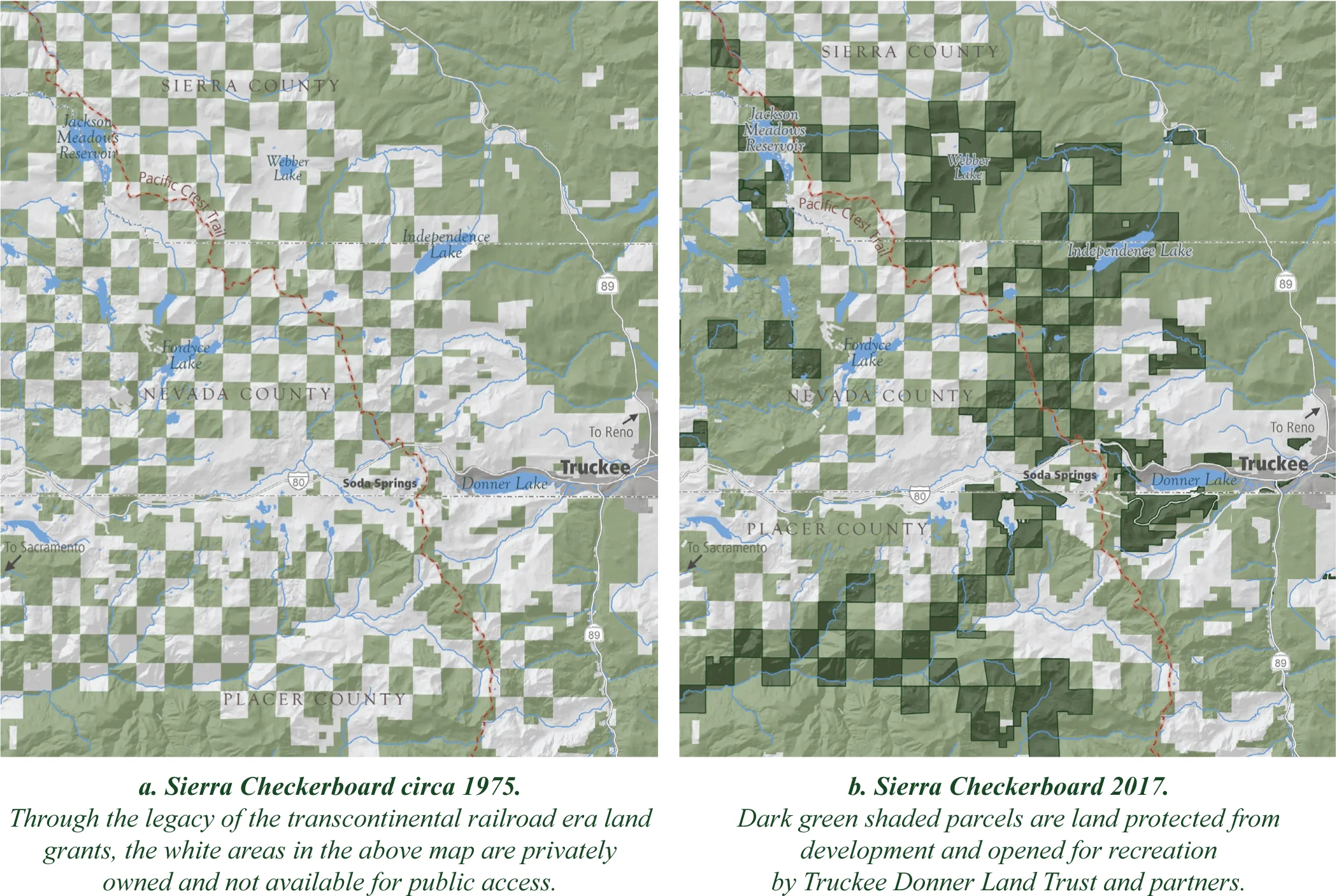
The “Sierra Nevada Checkerboard” is a mosaic spanning several thousand acres of land in public and private ownership, which resembles a checkerboard. This ownership pattern dates back to the construction of the transcontinental railroad in the 1860s. As an incentive to build this dangerous and expensive railroad, the federal government offered railroad companies every other square mile of land along the route, reserving the rest to become National Forest. If left unprotected, these private parcels of forestland will be converted to rural sprawl over the next 10 to 20 years, increasing congestion, decimating wildlife, and complicating fire management. “Closing” this Checkerboard is a Land Trust priority.
In 2006, the Land Trust and its steadfast partner, The Trust for Public Land, closed on 2,000 acres surrounding Independence Lake and 640 acres in the North Fork of the American River drainage that includes parts of Snow Mountain. This was the final phase of a project totaling nearly 4,000 acres. Other previously acquired properties include 1,400 acres in the Truckee River Watershed.
Perazzo meadows
The Land Trust’s portion of Perazzo Meadows totals 982 acres and was protected in 2008. These meadows are fine examples of wet meadow and riparian habitat in the Sierra, sustaining a number of rare species and playing a vital role in the Truckee River watershed. The property is well suited for hiking, bird watching and picnicking. Two picnic areas complete with interpretive signage are onsite.
Pierce Meadows
This 160-acre property, north of Eagle Lakes/Cisco Grove and west of Donner Summit, contains historic Pierce Meadows, popular for camping and horse packing. The parcel is a part of the Sierra Nevada Checkerboard and is an example of a 160-acre parcel now subdivided into 40-acre parcels. The meadows system is a significant contributor to the southern forks of the south Yuba River. These valuable meadow systems are an important source for water storage and water quality resources. An old network of passable roads and trails lead to a large granite cliff band. This astounding formation resembles a miniature El Capitan looming above the meadows.
Cold Stream Meadow
In partnership with The Trust for Public Land, the Land Trust closed escrow on 1,320 acres directly south of Perazzo Meadows. Within these two sections are over two miles of Cold Stream, supporting a healthy population of brook trout and a major tributary to the Little Truckee River. This acquisition also includes the 400-acre Cold Stream Meadow and over two miles of the popular Mt. Lola Trail. The property will remain a superior wildlife habitat with scenic views and public access for generations.
Devil’s Peak
This remote 960-acre property includes portions of Long Valley and Palisades Creeks, tributaries to the North Fork of the American River. A mix of red fir forest and chaparral near the crest of the Sierra, this property has long winters and snow on the ground well into summer. The Palisade Creek Trail offers the only access to the Devils Peak acquisition, which was conveyed to the U.S. Forest Service in 2009.
Snow Mountain
Totaling 640 acres or one square mile, Snow Mountain was protected in 2006 along with several other portions of the “Sierra Nevada Checkerboard”. The property is remote, rugged and inaccessible due to adjacent private property and topographical constraints. Snow Mountain is best viewed from Point Mariah on the Royal Gorge Property, or from Robinson Flat on Foresthill Divide Road.
Carpenter Ridge & Independence Lake
In partnership with The Nature Conservancy, the Land Trust completed a $15 million acquisition to protect the remaining 2,400 acres surrounding the stunning and pristine Independence Lake, north of Truckee. Independence Lake is home to one of two wild, self-sustaining populations of Lahontan cutthroat trout in the world and a prime source of clean drinking water for Western Nevada. The purchase of this property has been a 30-year priority for conservationists. With its partners, the Land Trust is implementing projects to restore the forests around the lake, will build a new campground, trails, trailheads and other recreational amenities to enhance public enjoyment. The surrounding pine forest is home to black bear, mountain lion, and mule deer. Bald eagles and osprey can be spotted from the shorelines hunting fish. The region is also home to rare species like the willow flycatcher, mountain yellow-legged frog, and Sierra Nevada mountain beaver. Click here to plan your visit!
The property is open year-round for walk in day use. Motorboats, kayaks and float tubes are no longer available for use at the Independence Lake Preserve in 2013. They will be available again beginning Memorial Day weekend in 2014, weather permitting.
Sunset magazine named The Truckee Donner Land Trust as one of their winners of Sunset's 2012 Environmental Awards, which are featured in the March, 2012 issue of Sunset. Independence Lake won in the category of "best lake or lakeshore preservation." As an award winner, we join the ranks of the most creative and effective environmental organizations in the West.
Henness Pass
In partnership with The Trust for Public Land, an historic agreement was reached with Sierra Pacific Industries to purchase conservation easements on 7,000 acres of lands along the northern Sierra Crest north of Truckee. This easement provides public access, recreation and trail development while allowing SPI to continue to own and sustainably manage the forested properties. Encompassing more than 11 square miles of private land, the deal creates a permanent, unbroken habitat, viewshed and recreational corridor along the length of Jackson Meadows Road closely paralleling historic Henness Pass Road.
Webber Lake & Lacey Meadows
Protected in 2012, Webber Lake/Lacey Meadows is 3000 acres of forests, mountain meadows, and Webber Lake, a 260-acre lake at the headwaters of the Little Truckee River. In terms of natural resource values, the Webber Lake and Lacey Meadows acquisition is the Land Trust’s most important to date. The meadow and uplands are open to the public for day-use, while the lakeshore and campground will continue to remain closed to the public until 2017. A hike along Lacey Valley Road, the trail traversing the property, offers a wildflower show in the summer, fall color in autumn, and chances to view high-country wildlife. The remnants of “Webber’s Station,” a once-popular gold rush hotel along the Henness Pass Road is located on the property.
Please note that although the property is currently open to the public, the lakeshore and campgrounds along Webber Lake remain closed until 20