
ROYAL GORGE

Photo by Bill Stevenson
After a remarkable grassroots fundraising campaign and difficult negotiations, the Land Trust acquired 3,000 acres on Donner Summit known as the Royal Gorge Property, along with 351-acres in Johnson Canyon above Donner Lake. With the help of over 1,000 donors, numerous public and private agencies, and our conservation organization partners, the Land Trust and its partners were able to raise the $11.25 million dollars needed to meet the five-month deadline to secure this property.
ACCESS ALERT
Van Norden Meadow Restoration begins June 15, ends October 31 2022-2024
Expect disruptions trail access, parking, and road access in the Van Norden Meadow Area. Hoelter Hall and Summit Station trailheads are not affected.
The acquisition of the Royal Gorge property might be one of the most important conservation victories for the Sierra in a generation, as the region was threatened by a proposed 950 housing units. Now all of Royal Gorge's remarkable meadows, peaks, and natural resources as well as the Nordic ski area have been protected forever and will be open to the public for world-class recreation.
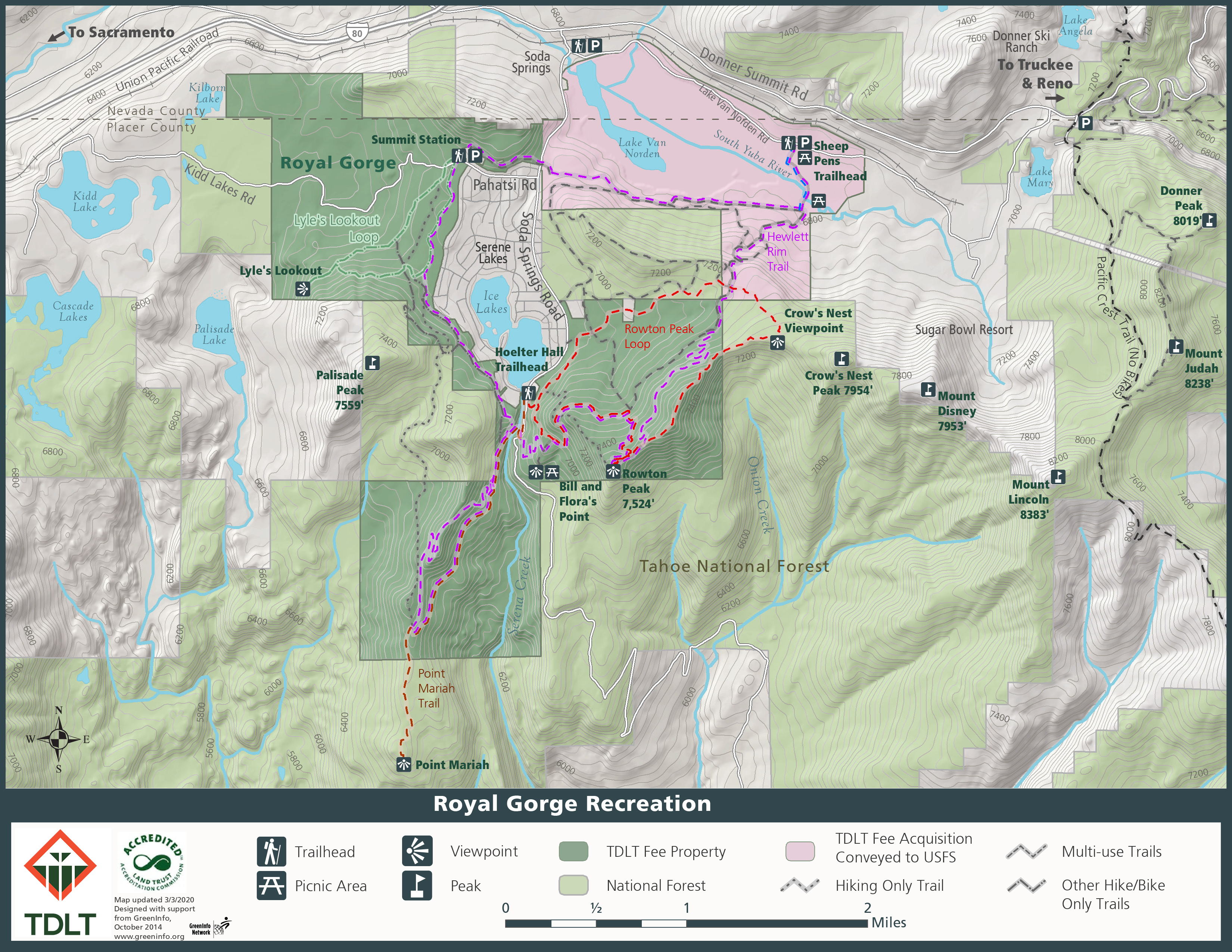
When out enjoying the trails at Royal Gorge please keep in mind that the map legends reflect what the future intended use is to be for individual trails and may not represent its current use designation. When in doubt, please be sure to just say “Howdy” to your fellow trail users.

field notes
COOL FACTOR
Summit Valley has a stunning history – from the spear points and rock art of the Martis Culture Native Americans and wheel ruts of the first wagon trains on the Overland Emigrant Trail to the tunnels and snow sheds of the transcontinental railway. The property is an important migration corridor and habitat for 20 species of mammals, at least 100 species of birds, more than 500 species of plants (including 16 special-status plants), and many species of butterflies. It is a vital piece of conservation and a nature-lover’s paradise.
WHAT TO DO
Year-Round, World Class Recreation
Managed by Sugar Bowl in winter, Royal Gorge offers a variety of snow sports and some of America’s best cross-country skiing with a 200-kilometer trail system and 7500 acres of terrain.
After the snow melts, the Nordic ski trails are open for hiking, biking and equestrians. The property abuts the 4,417-foot-deep Royal Gorge on the North Fork of the American River, where the North Fork cascades over cliffs to create numerous waterfalls and deep pools visited by robust hikers. Others may prefer the flower and butterfly-filled meadows and gentle forest walks.
These trails offer variety and spectacular scenery:
Lyle’s Lookout
A short three-mile hike from Summit Station provides a spectacular view of the iconic Devil’s Peak and the Land Trust’s Snow Mountain project. Map & full details.Rowton Peak
This moderately strenuous 5-mile hike leads through several wildflower and bird areas, offers expansive views of the Pacific Crest and the Granite Chief Wilderness, and passes through some impressive volcanic geology. Map & full details.Point Mariah
The highlight of this 5-mile moderate route is a viewpoint down 4,000 feet into the Royal Gorge of the North Fork of the American River. Map & full details.Royal Gorge Rim Trail
This 13-mile-long trail incorporates Lyle's, Rowton and Point Mariah - making it one of the premier mountain bike trails in the region. Features include great wildflowers headwaters of the American and Yuba rivers. Map
Smartphone navigation
The acquisition of the Royal Gorge property might be one of the most important conservation victories for the Sierra in a generation.
HOW TO GET THERE
From Interstate 80:
Exit at the Soda Springs/Van Norden off ramp. Proceed East toward Soda Springs/Van Norden on Old Highway 40 for one mile to a flashing light and turn right onto Soda Springs Rd.
From scenic Old Highway 40:
Drive along Highway 40 to Soda Springs and at the flashing light turn onto Soda Springs Rd.
Then proceed to your desired trailhead as described in the following:
Summit Valley History Trailhead:
After turning onto Soda Springs Road continue for 0.1 mile, crossing railroad tracks, where on the left you will see three parking areas, one after the other. Turn left into the SECOND parking area. It has telephone poles traversing it. Proceed under the telephone wires to the back of the parking area. You will see a gravel road exiting at the back. The Summit Valley History Trailhead is about 50 yards to the right of this gravel road and on the far side of a small berm opposite the old Van Norden Lake dam. The trail begins directly in front of the left side of the dam’s cement spillway and climbs to the top.
Lyle’s Lookout Trailhead:
After turning onto Soda Springs Rd, drive past the Royal Gorge parking areas on the left and go 0.9 miles to Pahatsi Rd. Turn right onto Pahatsi Rd and follow it to the end of the paved road. On your right you will see the Royal Gorge Summit Station (this is the main Royal Gorge lodge) and parking area entrance. Directly across the street on your left is the Summit Station Trailhead and parking area. This trailhead provides access to the Lyle’s Lookout Trail.
Hoelter Hall Trailhead for Rowton Peak and Pt. Mariah trail access:
Again continue on Soda Springs Rd. for exactly one mile beyond Pahatsi Rd. or 1.9 miles from the flashing light on Old Highway 40. You will see a small “Hoelter Hall Trailhead” sign on the left and a gravel road with an open gate. (If you have driven to the end of the paved road and there is a Placer County Maintenance sign at the beginning of a gravel road, you’ve gone about 0.3 miles too far.) Turn left at the trailhead sign and continue to the parking area at the end of the access road. This brings you to the Hoelter Hall Trailhead which provides access to the Rowton Peak and Pt. Mariah trails.
RULES, REGULATIONS, GOOD TO KNOW
No overnight camping
Nighttime uses are permitted as long as the Property is not used for camping
Unauthorized motor vehicles are not allowed on the Property
No fires of any kind are allowed. This includes camp stoves, smoking, campfires, fireworks or any kind of open flame
Wood cutting is prohibited without permission from the Truckee Donner Land Trust
Pack out your pet’s waste. Do not leave bagged pet waste anywhere on the Property, including on the trails or at the trailheads
Pack out all trash
Do not harass wildlife or allow your pet to harass wildlife
Please refer to the Royal Gorge map above for user restrictions on area trails
Please contact the Truckee Donner Land Trust regarding winter uses on the property
Respect the land and others who are enjoying the property. Remember “the spirit of howdy!” and take the time to greet others on the trail.